Otama Walking Trail ༄ᨒ
Nice, cool, easy hike along the Tama River in OkuTama, with a few waterfalls and a suspension bridge. Great for beginners or those seeking a relaxing stroll, especially in the summer months.
Getting there 🚂
Start station: Kori Station (JR Ome Line) 🚉
Finish station: OkuTama Station (JR Ome Line) 🚉
Travel from Shinjuku: about 1 hr 40 min ⏱️
- Ride the JR Chuo Line from Shinjuku toward Tachikawa, continue on the JR Ome Line toward OkuTama, and get off at Kori Station. 🚆
- The walking route starts a 5-minute walk from Kori Station.
TIP
Try taking the Holiday Rapid Okutama (休日快速 おくたま) train to get to Ome station faster from Shinjuku!
Trail overview 📋
- Difficulty: Easy - great for beginners! 🟢
- Toilets: Use the toilet at Kori Station before you start; Ecotto Shiromaru at Shiromaru Dam has another one later on. 🚻
- Drink: Bring plenty of water but there are a few cafes and stores along the way.
- Convenience store: 7-Eleven near Kori station
- Lunch: Few food options along the trail, so pack your own. 🍱
- Hiking poles 🔧: 2 / 5
- Not needed; the route is a riverside walkway with steps, not a mountain trail.
- Trail running 👟: 3 / 5
- Mostly runnable with a few narrow and rocky sections in the Hatonosu Valley.
- Best season: Spring to autumn; the shaded river path stays cool even on hot summer days. 🍃
- Bail-out point: Hatonosu Station /
鳩ノ巣駅sits partway along the route, so you can stop there early or use it as a shorter start. 🚉 - ⚠️ The stretch between Kori Station and Hatonosu Station includes long paved-road sections, so watch for cars.
- ⚠️ The rocks in Hatonosu Valley are very slippery when wet, so wear shoes with good grip.
Trail route 🥾
- Kori Station /
古里駅 - Suniwa Bridge /
寸庭橋 - Hatonosu Valley /
鳩ノ巣渓谷 - Shiromaru Dam /
白丸ダム - Kazuma Gorge /
一ノ瀬渓谷 - OkuTama Station /
奥多摩駅
- The route also works in reverse, from OkuTama Station to Kori Station.
- My recorded hikes on YAMAP:
- Otama Walking Trail - June 2024 hike ~6 hr, 9.7 km 🗻
- OkuTama river walk on a hot summer day - August 2025 hike ~4.5hr, 9.4 km 🗻
Metrics:
- Duration: 4:35 to 6:15
- Distance: 9.4 km to 9.7 km
- Elevation gain ↗: 601 m to 624 m
- Elevation decline ↘: 544 m to 571 m
- Trail type: Point to point (one way)
Map of the route 🗺️
The OkuTama Tourist Association publishes the official trail map:
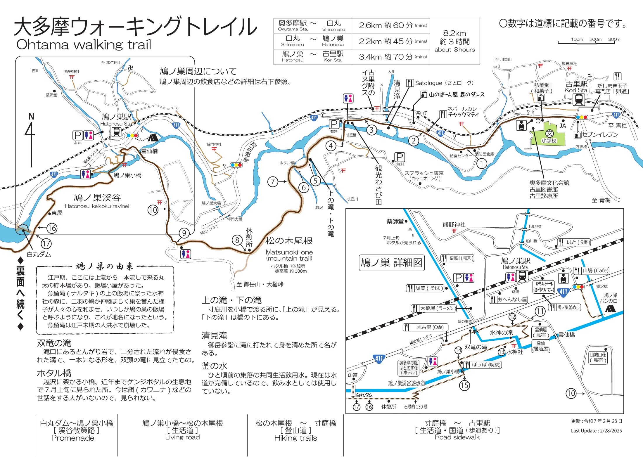
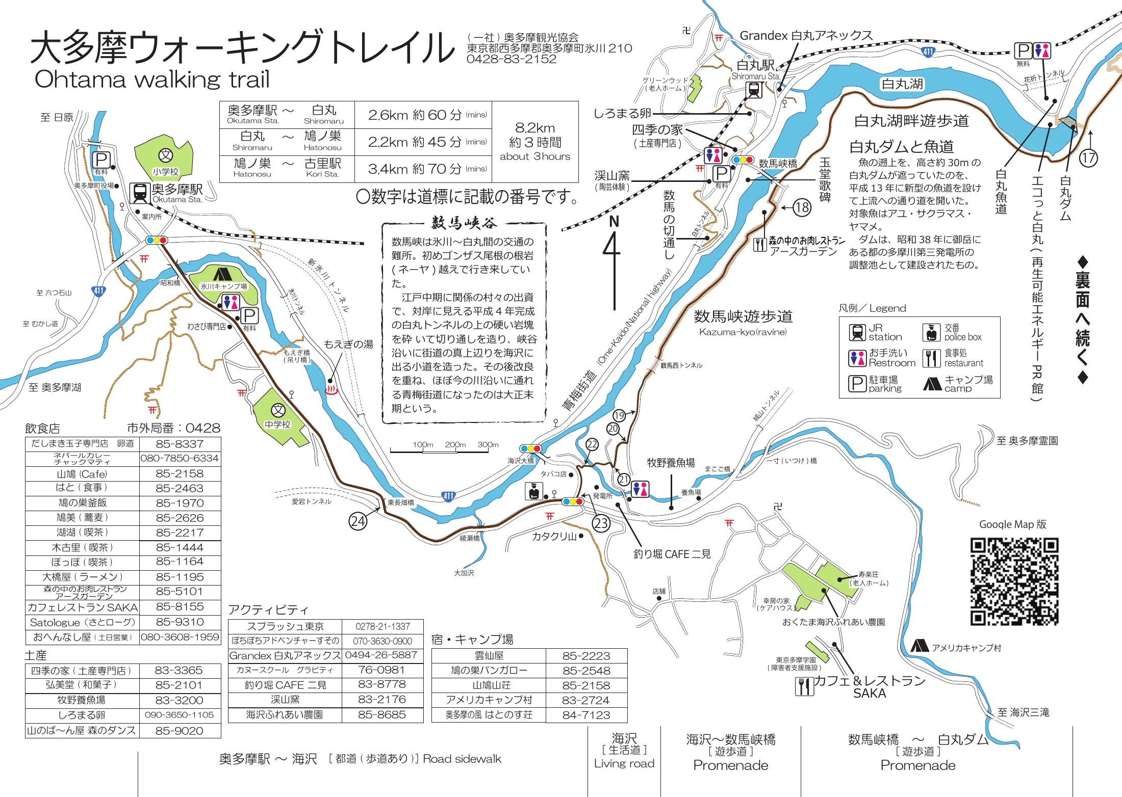
Other versions of the map:
Shoutout to OkuTama Tourist Association for making the PDF and Google maps! 👏
Shortcuts ✂️
Skipping the paved section between Kori station and Shotanba parking lot
Unfortunately, the stretch between Kori Station and the Shotanba Sightseeing Parking Lot / 小丹波観光駐車場 is a 17-minute walk on a paved road.
To avoid this, start from Hatonosu Station instead for a shorter hike, though you will encounter dirt trails within 5 minutes.
Skipping the road between Lake Shiromaru and OkuTama station
When you pass Earth Garden / 森の中のお肉レストラン アースガーデン, the route becomes a local village road until you reach OkuTama Station.
To avoid this, cross the bridge near Earth Garden to head to Shiromaru Station / 白丸駅, then take the train to OkuTama Station.
Minimum pavement route
- My September 2025 record starts at Hatonosu Station, hike to Shiromaru Station /
白丸駅, then take the train to OkuTama Station and then walk around the OkuTama station rea. - You still see the highlights: Hatonosu Valley, Shiromaru Dam, and the Kazuma Gorge walkway.
Nice riverside paths near OkuTama station
Walk towards Tokei Bridge / 登計橋 for nice views of the river.
Timeline ⏱️
The times below come from my June 2024 hike.
- 10:09 - Depart Kori Station. 🚉
- 10:26 - Pass the Kotaba tourist parking lot. 🅿️
- 11:45 - Pass Hatonosu Station, the bail-out point. 🚉
- 11:53 - Explore Hatonosu Valley and its suspension bridge. 📸
- 12:58 - Reach Shiromaru Dam. 💧
- 13:38 - Leave the dam and follow the walkway along Shiromaru Lake /
白丸湖. - 15:52 - Pass the OkuTama Junior High School bus stop /
奥多摩中学校バス停at the edge of town. 🚏 - 16:22 - Arrive at OkuTama Station. 🚉
Food 🍱
Food options along this trail are few, so bring lunch and snacks with you. 🍙
- Harashima Shokudo /
はらしま食堂- a diner right next to Kori Station. 🍜 - Hatonosu-so /
はとのす荘- a riverside lodge above Hatonosu Valley. ♨️ There is no lunch for day visitors, but you can use the day-time hot spring bath from 11:30 to 15:00, with last entry at 14:30, for 1,370 yen per adult. - Ecotto Shiromaru /
エコっと白丸- a free public exhibit hall at Shiromaru Dam about hydropower, with a toilet, vending machines, and ice cream. 🍦 - Moegi no Yu /
もえぎの湯- a hot spring facility just before OkuTama Station, a nice way to end the hike. ♨️
Key photo spots 📸
Giant inugusu tree /
古里附のイヌグス🌳
One of the largest trees of its kind in Japan, squeezed between the train line and the road near Kori Station.Suniwa Bridge 🌉
The crossing to the quiet riverside path, with the small Upper Falls /上の滝just beyond.Soryu Falls /
双竜の滝💧
A waterfall right behind Hatonosu Station, where the water falls in two dragon-like streams.Hatonosu suspension bridge /
鳩ノ巣小橋🌉
A small suspension bridge at the entrance to the rocky gorge.Hatonosu Valley 📸
One of the 30 selected views of the Tama River; the name means "dove's nest".Shiromaru Dam and Shiromaru Lake 💧
The dam has a fish ladder, and a calm walkway follows the lake behind it. You can also go a bit inside the dam from the Shiromaru Dam promenade /白丸ダム遊歩道, where a spiral staircase drops about 27 m to the fish ladder, one of the largest in Japan at 330 m long. Entry is free, and the staircase usually opens on weekends, public holidays, and during the summer holidays.
References 📚
- Otama Walking Trail map (PDF) by the OkuTama Tourist Association. 🗾
- Route description in English: Otama Walking Trail hike from Kori to OkuTama. 📝
- Route description in Japanese: Hatonosu Valley walk on Tachikawa Online. 📝
Found it helpful?
Consider buying me coffee ☕ ~
Your support fuels more adventures and guides. Thank you!