Kumano Kodo trip itinerary
5 day hiking trip itinerary for Kumano Kodo trail in Wakayama
Table of contents
- Overview
- YAMAP model courses
- Plane tickets
- Day 1: Flying to Shirahama City
- Day 2: Bus and hiking; Shirahama City to Takahara Village
- Day 3: Hiking; Takahara to Chikatsuyu
- Day 4: Hiking and bus; Chikatsuyu to Hongu Taisha
- Hike: Chikatsuyu to Kumano Hongu Taisha
- Day 5: Boat tour and return to Shirahama City
- Resources
Overview
| Day | What | Hotel |
|---|---|---|
| Day 1 | Flying in and spending the night | |
| Day 2 | Bus and hiking to Takahara | Kirinosato Takahara |
| Day 3 | Hike to Chikatsuyu | Guest House Minshuku Momiji-no-Sato |
| Day 4 | Bus and hike to Yunomine Onsen | Minshuku Kuraya |
| Day 5 | Boat and bus to Shirahama City | |
| Day 6 | Beach at Shirahama City | |
| Day 7 | Beach at Shirahama City | |
| Day 8 | Fly back |
YAMAP model courses
- Kii-Tanabe Station - Inabane Oji / 紀伊田辺駅~稲葉根王子 - YAMAP
- Inabane-Oji ~ Takijiri-Oji / 稲葉根王子~滝尻王子 - YAMAP
- Shimomisu - Peeking Bridge / 下三栖~覗橋 - YAMAP
- Takijiri-Oji ~ Tsugusakura-Oji / 滝尻王子~継桜王子 - YAMAP
- Tsugizakura Oji ~ Kumano Hongu Taisha Shrine / 継桜王子~熊野本宮大社 - YAMAP
- Akagigoshi / 赤木越 - YAMAP
- Dainichietsu / 大日越 - YAMAP
Plane tickets
Tokyo to SHM
- Monday, May 24, 16:30 to 17:40
SHM to Tokyo
- Monday, May 31, 09:20 to 10:25
Day 1: Flying to Shirahama City
Flight
- Haneda to Nanki-Shirahama (SHM) Airport / 南紀白浜空港
- 1 hour 10 minutes
- 23,000 yen per person
Overnight
- Option 1: Asso Station / 朝来駅
- Option 2: Kii-Tanabe Station / 紀伊田辺駅 area
Day 2: Bus and hiking; Shirahama City to Takahara Village
Bus
- Nanki-Shirahama to Takijiri / 滝尻 bus stop
- 1.5 to 2 hour ride
- 91 Rapid (Kumano Kodo) for Shingu Station
- Kumano Kodo Information Center / 熊野古道館
Hiking: Takijiri-Oji to Takahara
- Distance: approximately 4 km
- Time: 2 to 3 hours
- Elevation gain ↗️: approximately 430 m
- Elevation decline ↘️: approximately 200 m
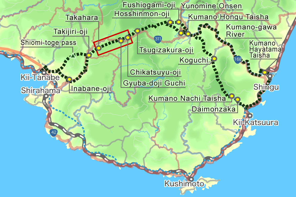
- Short but steep uphill walk from Takijiri to the ridge top settlement of Takahara.
- The trailhead is behind the Takijiri-Oji shrine pavilion.
- The trail starts off steep, so set a slow, steady pace and watch your steps on rocks and roots.
Overnight: Takahara Village
- Kiri-no-Sato Takahara Lodge "Organic Hotel" - Kumano Travel
- Kiri-no-Sato Takahara Lodge - Booking.com
- Kirinosato Takahara - Google Maps
Day 3: Hiking; Takahara to Chikatsuyu
Hiking: Takahara to Chikatsuyu
- Takahara
- Chikatsuyu
- Distance: approximately 10 km
- Time: 4 to 6 hours
- Elevation gain ↗️: approximately 590 m
- Elevation decline ↘️: approximately 640 m
Rest stop on Kumano / 牛馬童子像休憩所 This walk continues into forested mountains east of Takahara, climbing ridges and descending into Chikatsuyu.
Note: The Michi-no-Eki rest area near signpost 23 sells drinks, snacks, and simple meals.
Overnight: Chikatsuyu Village
- Kumano Travel: Minshuku Momiji-no-Sato
- Google Maps: Guest House Minshuku Momiji-no-Sato
Day 4: Hiking and bus; Chikatsuyu to Hongu Taisha
Hike: Chikatsuyu to Kumano Hongu Taisha
- Three options are available for the hike.
- For detailed comparison: Walk options PDF
- Bus timetable #1
Overnight: Yunomine Onsen
- Kumano Travel: Minshuku Kuraya
- Google Maps: Minshuku Kuraya
Option 1: Full walk; 25 km
- Distance: approximately 25 km
- Time: 9 to 12 hours
- Elevation gain ↗️: approximately 1210 m
- Elevation decline ↘️: approximately 1470 m
This is a challenging full-day walk with many climbs and descents, finishing at Kumano Hongu Taisha.
Start early if attempting the full walk.
Option 2: Challenging walk; 17 km
Bus: Chikatsuyu to Doyukawa-Bashi
- Doyukawa-Bashi / 道湯川橋 bus stop
- Ryujin Bus
- Depart: 7:23 Chikatsuyu-Oji
- Arrive: 7:33 Doyukawa-Bashi
- Price: 280 yen
Hike: Doyukawa-Bashi to Hongu Taisha
- Hongu Taisha
- Distance: approximately 17 km
- Time: 6 to 9 hours
- Elevation gain ↗️: approximately 770 m
- Elevation decline ↘️: approximately 1170 m
Option 3: Highlight walk; 7.5 km
Bus: Chikatsuyu to Hosshinmon-Oji
- Hosshinmon-Oji / 発心門王子 bus stop
- Ryujin Bus
- Depart: 7:23 Chikatsuyu-Oji
- Arrive: 8:37 Hosshinmon-Oji
- Price: 960 yen
Hike part 1: Hosshinmon-Oji to Hongu Taisha
- Distance: approximately 7.5 km
- Time: 2 to 3 hours
- Elevation gain ↗️: approximately 190 m
- Elevation decline ↘️: approximately 460 m
This section from Hosshinmon-Oji to Hongu is popular, with forested trails and settlement scenery. It is a good option for those who want time to explore the shrines and sites in Hongu.
Hike part 2: Hongu to Yunomine Onsen
- Dainichi-goe route
- Distance: approximately 2 km
- Time: 1 to 2 hours
Day 5: Boat tour and return to Shirahama City
Bus: Yunomine Onsen to boat tour center
- Michi-no-Eki Kumanogawa / 道の駅熊野川
- Depart: 8:31 Yunomine Onsen
- Arrive: 9:08 Michi-no-Eki Kumano-gawa
- Price: 950 yen
Boat: traditional ride on the Kumano-Gawa River
- Kumano Hayatama Taisha / 熊野速玉大社
- Kumano traditional boat tour
- 10:00 to 11:30
- Arrive by 09:30 for boarding.
Detour: Nachi Falls / 那智の滝
- 1.5-hour bus ride from Hayatama Taisha to Nachi Falls
Overnight: Shirahama City
Resources
Videos: Trail logistics - how to plan and book the Kumano Kodo Trail
Kumano Travel
- Main site: https://www.tb-kumano.jp/en/kumano-kodo/
- Nakahechi route PDF map booklet
- Reservation site: https://www.kumano-travel.com/en
- Video by Alain Stewart: https://bit.ly/33oevW5
- Overview of Kumano Kodo trails with transport: https://bit.ly/32EDuD6
- Hongu to Koguchi bus timetables: https://bit.ly/2QyYndl
- https://www.insidekyoto.com/kumano-kodo-walking-trail-guide-with-maps
- Kumano Kodo trek - 4 days - Nakahechi, Takijiri to Hongu - 2
Found it helpful?
Consider buying me coffee ☕ to support my hiking and documentation efforts!
Your support fuels more adventures and detailed guides. Thank you!