Hinatawada Station to Mitakesan Cable Car via Mt. Hinode (日の出山) Route
- Great trail for beginners who want something a little more challenging than Mt. Takao
- Good for summer hikes as there are many shaded areas
- If you are lucky, you may spot a Japanese serow 🦌
Metrics
| Metric | Value |
|---|---|
| Length of time | 06:37 |
| Distance | 9.9km |
| Elevation gain ↗️ | 1031m |
| Elevation decline ↘️ | 400m |
| YAMAP Strength | 2 out of 5 |
| Hiking Poles? | Optional |
| Hiking Shoes? | Optional |
Key Locations
Getting There:
- 09:25 - Take the train from Tachikawa Station to Ome Station
- 09:55 - Arrive at Ome Station
青梅駅- Buy lunch at 7-11 or Origin Bento
- 10:12 - Ome Station to Yoshino-Bairin by Bus 🚌
- 10:24 - Arrive at Yoshino-Bairin Bus Stop
Start Options:
- Train 🚉 Hinatawada Station (
日向和田駅) - Bus 🚌 Yoshino-Bairin (
吉野梅林) - Trailhead 🥾 (
日の出山 御岳山登山口/吉野梅郷登山口)
Goal (End of Hike):
Mitakesan Cable Car Station (御岳山駅)
Return to Tokyo:
- Mitakesan Cable Car Station (
御岳山駅) - Takimoto cable car Station for Mt. Mitake (
御岳登山鉄道 滝本駅) - Mitake Station Bus Stop (
御岳駅(バス)) - Mitake Station (
御嶽駅)
Mountains & Views: (in order):
- Mt. Mimuro (
三室山) - Kotohira Shrine (
琴平神社) - Mt. Yogai (
要害山) - Umenoki Pass (
梅野木峠) - Fork in the Road
- Mt. Takamine (
高峰山) - Mt. Ryunohige (
竜のヒゲ) - Mt. Hinode (
日の出山) - Musashi Mitake Shrine's Torii Gate (
武藏御嶽神社 鳥居) - Mt. Mitake (
御岳山)
Toilets 🚽 (in order):
- Umeno Park Public Toilet
- Toilet by the Trailhead for Mt. Mimuro (
三室山) - Hinodeyama Park Toilet (
日の出山園地トイレ) - Mitakesan Public Restroom (
御岳丸山園地便所) - Mitakedaira Park Toilet (
御岳平園地便所)
Timeline / Check-in Points
- 10:35 - Trailhead 🥾
- 11:45 - Kotohira Shrine (
琴平神社) - 13:00 - Umenoki Pass (
梅野木峠) - 13:35 - Mt. Takamine (
高峰山) - 14:00 - Mt. Ryunohige (
竜のヒゲ) - 15:00 - Mt. Hinode (
日の出山) - 16:30 - Finish at Mitakesan Cable Car Station
Route Details
YAMAP Plan:
Hinatawada Station -> Mitakesan Cable Car - YAMAP
Example YAMAP Trip:
YAMAP Route:
Mt. Hinode - Umenoki Pass - Hinatawada Station Longitudinal Course
日の出山-梅野木峠-日向和田駅 縦走コース - YAMAP
Google Maps List:
Hinatawada Station to Mitakesan Hike - Google Maps:
Mitakesan cable car
Mountain top station: Mitakesan Cable Car Station / 御岳山駅
Base station: Takimoto Station / 滝本駅
Closest train station: JR Mitake Station / 御嶽駅
- Take a bus from JR Mitake Station to Takimoto Station.
JR Mitake Station to Mitakesan Cable Car Station route map: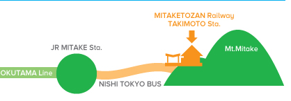
graph TD
    A["JR Shinjuku station 🚉"] -->|"Okutama line 🚃"| B["JR Mitake station 🚉"]
    B -->|"Nishi Tokyo Bus 🚌"| C["Takimoto cable car station 🚉"]
    C -->|"Mitaketozan railway 🚠"| D["Mitakesan cable car station 🚠"]
Phone numbers:
- Mitake Tozan Railway: 0428-78-8121
- Nishi Tokyo Bus (Haigawa Office): 0428-83-2126
Cost:
- 1,200 yen round trip (adult)
- 600 yen one way (adult)
Mitakesan cable car timetables
🚠 The last cable car down from Mt. Mitake is at 18:30. ⚠️
| Hour | Weekdays | Weekends and holidays |
|---|---|---|
| 07 | 30, 55 | 30, 54 |
| 08 | 20, 40 | 10, 26, 42, 58 |
| 09 | 00, 20, 40 | 14, 30, 46 |
| 10 | 00, 20, 40 | 02, 18, 42, 58 |
| 11 | 10, 45 | 14, 46 |
| 12 | 10, 40 | 02, 18, 42 |
| 13 | 10, 40 | 14, 46 |
| 14 | 10, 42 | 18, 50 |
| 15 | 00, 20, 42 | 06, 22, 38, 54 |
| 16 | 06, 30 | 10, 34, 58 |
| 17 | 00, 30 | 30 |
| 18 | 00, 30 | 00, 30 |
- Timetable as of 2025-10-11.
- For more details, see mitaketozan.co.jp/timetable.html.
Found it helpful?
Consider buying me coffee ☕ to support my hiking and documentation efforts!
Your support fuels more adventures and detailed guides. Thank you!