OkuTama Station to Mitakesan Cable Car via Nokogiri, Odake, and Mitake (鋸山, 大岳山, 御岳山)
Hiking route from Okutama Station (奥多摩駅) to Mitakesan Cable Car Station (御岳山駅) via Mt. Nokogiri (鋸山), Mt. Odake (大岳山), and Mt. Mitake (御岳山)
Metrics
- Length of time: 08:58
- Distance: 11.6 km
- Elevation gain ↗️: 1,440 m
- Elevation decline ↘️: 938 m
Locations
- Start: Okutama Station / 奥多摩駅
- Goal: Mitakesan Cable Car Station / 御岳山駅
- Mt. Nokogiri (鋸山)
- Mt. Odake (大岳山)
- Mt. Mitake (御岳山)
Timeline
- 09:00 - Start at Okutama Station
- 17:58 - Finish at Mitakesan Cable Car Station
Route
Mitakesan cable car
Mountain top station: Mitakesan Cable Car Station / 御岳山駅
Base station: Takimoto Station / 滝本駅
Closest train station: JR Mitake Station / 御嶽駅
- Take a bus from JR Mitake Station to Takimoto Station.
JR Mitake Station to Mitakesan Cable Car Station route map: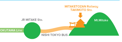
mermaid
graph TD
    A["JR Shinjuku station 🚉"] -->|"Okutama line 🚃"| B["JR Mitake station 🚉"]
    B -->|"Nishi Tokyo Bus 🚌"| C["Takimoto cable car station 🚉"]
    C -->|"Mitaketozan railway 🚠"| D["Mitakesan cable car station 🚠"]
Phone numbers:
- Mitake Tozan Railway: 0428-78-8121
- Nishi Tokyo Bus (Haigawa Office): 0428-83-2126
Cost:
- 1,200 yen round trip (adult)
- 600 yen one way (adult)
Mitakesan cable car timetables
🚠 The last cable car down from Mt. Mitake is at 18:30. ⚠️
| Hour | Weekdays | Weekends and holidays |
|---|---|---|
| 07 | 30, 55 | 30, 54 |
| 08 | 20, 40 | 10, 26, 42, 58 |
| 09 | 00, 20, 40 | 14, 30, 46 |
| 10 | 00, 20, 40 | 02, 18, 42, 58 |
| 11 | 10, 45 | 14, 46 |
| 12 | 10, 40 | 02, 18, 42 |
| 13 | 10, 40 | 14, 46 |
| 14 | 10, 42 | 18, 50 |
| 15 | 00, 20, 42 | 06, 22, 38, 54 |
| 16 | 06, 30 | 10, 34, 58 |
| 17 | 00, 30 | 30 |
| 18 | 00, 30 | 00, 30 |
- Timetable as of 2025-10-11.
- For more details, see mitaketozan.co.jp/timetable.html.
Found it helpful?
Consider buying me coffee ☕ to support my hiking and documentation efforts!
Your support fuels more adventures and detailed guides. Thank you!